Description
How To Get A Quote
***Online pricing not available, Please request a quote:***
How To Get A Quote:Option 1:Contact Us to make sure you are getting the best unit possible. These machines are complex so let us help you get exactly what you need!
Option 2: (quickest response times)Step 1. Add the item to your cartStep 2. Checkout or Click on the Chat button box that is at the bottom right of your screenStep 3. Please tell us any info you think we would need to knowStep 4. Relax, our team is processing your request and an expert will be in touch to get you exactly what you need!
Product Description
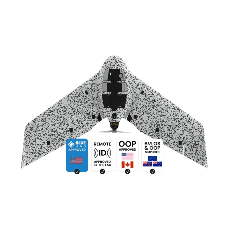
AgEagle eBee TAC Tactical Mapping Drone | 3.5 lbs Weigth | For Military & Governmental Use
DESCRIPTION
Blue UAS registered
Cyber-secure governmental and tactical mapping drone
Perform in disconnected environments to act precisely. eBee TAC can be operated by one person and deployed in 3 minutes. 3D models, thermal and orthomosaics maps sharable locally.
- 1.5 cm / 0.6 in mapping accuracy
- 90 minutes flight time
- 500 ha / 1,235 ac in a single flight
- 1.6 kg / 3.5 lbs
Specially designed for situation awareness
Why eBee TAC
Fully operational and approved solution
Blue UAS registered by U.S. DoD
eBee TAC is thefirst fixed-wing approved droneto be added to the Defense Innovation Unit (DIU) Blue UAS Cleared List for procurement by the U.S. Department of Defense (DoD) and government agencies.
Systems added to this list do not require a Department of Defense exception to operate, as they have undergone an evaluation of the drone systems capabilities, NDAA compliance, operational safety and cyber security.
Used by armed forces worldwide
U.S. Army Engineering and Support
U.S. Army Corps of Engineers
French Navy
Land Army of France
British Army
Royal Danish Army
Easy to use tactical drone
-
Operated by one person
Easy to use, easy to train. eBee TAC can be operated by one person.
-
IP67 military transport case
Easily transported in a hard transport case with STANAG certification.
-
Easy maintenance
Maintained without requiring external support.
-
3 minutes deployment
Standalone and PPK deployment, 3 minutes. With RTK, 10 minutes.
eMotion Flight management software
Easy to use, with advanced features. All the functionality you need to collect and manage geospatial data to act with precision.
-
3D flight planning
Plan, simulate and control advanced missions in any terrain, including mountainous areas. Automated flight and landing.
-
Full covert mission
Covert option allows you to perform silent radio missions with undetectable radio.
-
Live flight plan change
Easily hold the drone in position, adjust the flight path and/or the landing spot during flight.
-
Multi-drone operations
Fly up to 4 drones at the same time, all controlled from 1 ground control station.
-
Offline planning
Fly in disconnected environments thanks to offline background maps and elevation data.
-
Optimized modes
Horizontal, corridor, point of interest (POI), multiple or fully custom mission blocks.
Being able to adjust or change the flight plan with eMotion during the flight is one of the most valuable features to us. For example, we recently had to do a mission with our eBee TAC near an aid and rescue helicopter that had 7 minutes to take off in case of an emergency. With eMotion, we were able to clear the helicopter flight area in a couple of minutes, avoiding any potential risk.
– Major –
Proven reliability
eBee TAC is purpose-built for the tactical mapping demands of defense applications to improve mission effectiveness in a variety of terrains.
The hardware, software, cybersecurity and reliability of the product have beenassessed by the U.S. Defense Innovation Unit (DIU).
12 years
Industry experience
173,600 +
Cumulated flights
90,490 +
Flight hours
1/1,750 hours
Fly away probability
Safe operations
eBee TAC drone meets the highest possible quality and ground risk safety standards and has demonstrated operational safety around people.
-
BVLOS approved
eBee drones have been granted Beyond Visual Line of Sight (BVLOS) operationspermission in Brazil.
-
Flights over people
Approved to run Operations Over People(OOP) in Canadaand in theUnited States.
-
SORA process
eBee drones are thefirst to receive M2 Mitigation Design Verification for SORAprocess from the European Aviation Agency (EASA), essential for advanced operations.
Safety tests
- Safety impact tests performed to demonstrateoperational safety around people.
- Free from hard front plastic parts and no front-facing motor.
- Flight planning software integrates fail-safe protocols.
- Live air traffic awareness with Ping USB accessory.
Rugged and durable solution
Drone underbody skin made of durable Curv Polypropylene thermoplastic composite. A shock-absorbent construction that endures continuous linear landings without damaging the drone, even in harsh terrain.
eBee TAC has a modular design that allows easy maintenance and fast repairs in the field.
NDAA compliant
eBee TAC is compliant to the National Defense Authorization Act (NDAA) of the U.S. federal law, an essential requirement to prevent maliciously hacking.
The drone components, hardware and software, are not from any of the blacklisted companies or countries, and the connectable solution has been proven cyber-secure.
Tactical mapping partnership
ARTEMIS solution created in collaboration with Hexagon US Federal and Tough Stump Technologies.
ThisAerial Reconnaissance Tactical Mapping and Imagery System kitavailable for the U.S. includes the eBee TAC drone, Google Earth Enterprise Platform (GEEP) and can be integrated with situational awareness tools such as ATAK.
Post-processing compatibility
Once the data is collected by the drone, the images are post-processed with a wide range of compatible software to generate the 2D and 3D maps.
Key Features
Mission ready UAS
Validated cyber-secure
- Radio data link with AES-256 encryption
- Drone log file suppression
- Encrypted SD card
- Silent radio mission
- Low visible signature at 300 m / 984 ft AGL
- Acoustically undetectable at 300 m / 984 ft AGL
- Integrable with Google Earth Enterprise (GEEP)
- Designed and assembled in Switzerland
-
90 minutes flight time
Efficiently map up to 500 ha / 1,235 ac while flying at 120 m / 400 ft.
With a flight time of 90 minutes and a flight range of 55 km / 34 mi, eBee TAC can cover large and inaccessible areas.
-
Takeoff weight 1.6 kg / 3.5 lbs
Thanks to its light weight, eBee TAC fixed-wing has the best ratio energy/MTOW compared to heavier VTOL drones, offering better energy efficiency.
-
3D and thermal mapping
eBee TAC swappable cameras allow you to collect data that can be used via the encrypted SD card for analysis and decision-making.
Camera options include RGB, 3D (patented) and thermal payloads for night flights.
-
1.5 cm / 0.6 in accuracy
WiththeRTK / PPKoptional software, the tactical mapping drone achieves an absolute accuracy down to 1.5 cm / 0.6 in, without ground control points (GCPs).
-
MGRS coordinates
eMotion drone management software for eBee TAC includes the Military Grid Reference System (MGRS), the geocoordinate standard used by NATO.
Hardware and software included
What you’ll get
IP67 military transport case
Encrypted SD cards
Flight management software